
Free Camping in Washington State: What to Know Before You Go
Free camping in Washington State is legal, it is everywhere, and there is more of it here than in almost any state in the West. The national forests alone cover more than 9 million acres, and across most of that ground you can pull off a gravel road tonight and sleep for free, legally, without telling anyone you are coming.
The catch is that the map moves every summer, and nobody sends out a notice.
Before you go. Fire restrictions land on most of Washington’s public land somewhere between early July and mid September in a normal year, and they lift somewhere between late September and the first real rain. Closure orders come and go on top of that, and they can shut roads and campgrounds well outside anything actually burning. Neither runs on a calendar you can plan around a year out.
Washington fire conditions right now
Checked 1 second ago, at 7:18 pm on October 12. This page checks DNR on its own every few hours. Source: Washington DNR.
Burn restrictions are in effect in 6 of Washington DNR's 23 fire danger areas.
| Fire danger area | Danger | Outdoor burning |
|---|---|---|
| Northeast region | ||
| Foothills | Moderate | Restrictions in effect |
| Highlands | Moderate | Restrictions in effect |
| Kaniksu | Moderate | Restrictions in effect |
| Methow | Moderate | Restrictions in effect |
| Upper Basin | Moderate | Restrictions in effect |
| Northwest region | ||
| North Cascade | Low | None posted |
| North Lowlands | Low | None posted |
| Olympic region | ||
| Coast | Low | None posted |
| Olympics | Low | None posted |
| Pacific Cascade region | ||
| Gorge West | Low | None posted |
| South Lowlands | Low | None posted |
| South WA Cascades | Low | None posted |
| Vancouver | Low | None posted |
| South Puget Sound region | ||
| Central Lowlands | Low | None posted |
| Central WA Cascades | Low | None posted |
| Southeast region | ||
| Blue Mountain Grass and Brush | Moderate | None posted |
| Chelan | Moderate | None posted |
| Lower Basin | Moderate | None posted |
| Lower Yakima | Moderate | None posted |
| Northern Blue Mountains | Moderate | None posted |
| Upper White Salmon | Moderate | Restrictions in effect |
| Upper Yakima | Moderate | None posted |
| Valley | Moderate | None posted |
These are DNR's fire danger areas, covering state and private land. They do not line up with national forest boundaries, and every national forest sets its own restrictions separately. If you are camping on federal land, check that forest's alerts page as well. Full detail and daily changes: DNR burn portal.
Free camping is the first tier of public land to close and the last to be announced. Free sites are unstaffed, unreserved, and have no reservation list to email when something changes. A state park will tell you it closed. A pull off on a forest road will not. That is worth understanding before you plan a weekend around any list of free campsites, including this one.
Is Free Camping in Washington State Legal?
Yes. Free camping in Washington State is legal on federal and state public land, under two arrangements. Dispersed camping means pulling off a road onto undeveloped public land with no site, no table, no toilet, and no fee, and it is allowed on most national forest and BLM ground. Free campgrounds are actual developed sites with a fire ring and a vault toilet that simply do not charge a nightly fee, and Washington has more of these than most people realize.
What is not legal is camping wherever you feel like it. Every acre in this state belongs to somebody, and which somebody it is determines your stay limit, your fire rules, and whether your parked truck needs a pass on the dash.
The Five Agencies That Run Free Camping in Washington
There are five of them. Most people can name two.
National Forest Dispersed Camping
This is where the majority of Washington’s free camping lives. Seven national forests cover the state, counting two that cross state lines: Olympic on the west side, Mt. Baker-Snoqualmie in the north Cascades, Okanogan-Wenatchee on the dry east slope, Gifford Pinchot in the south Cascades, Colville in the far northeast, Umatilla in the southeast corner shared with Oregon, and the Washington sliver of the Idaho Panhandle forests, which older maps still label Kaniksu.
Camping itself is free and needs no permit. The standard rules: 14 days in a 30 day period within one ranger district, at least 200 feet from any water source, camp in a spot somebody has already used rather than making a new one, and pack everything out. Olympic National Forest is the outlier and runs a more generous 21 consecutive days, but adds a rule the others do not have, requiring your site to sit at least a quarter mile from any developed campground, picnic area, or trailhead.
The thing that trips people up is parking. Camping is free. Parking at a fee trailhead is not, and that is what the Northwest Forest Pass is for.
DNR Campgrounds and State Forests
Washington’s Department of Natural Resources runs about 80 campgrounds on state trust lands, spread across both sides of the Cascades, and the nightly fee is zero. These are real campgrounds with fire rings and vault toilets, not roadside pull offs. They are first come, first served with no reservations, apart from a handful of bookable sites at the Elbe Hills ORV campground.
The catch is the pass. There is no camping fee, but your vehicle needs a Discover Pass to be parked there, so this is free camping with a parking charge rather than free camping outright. Stay limits run 10 days in a 30 day period unless a sign says otherwise, and several forests post something shorter. Dispersed camping is permitted on some DNR forests and flatly prohibited on others.
DNR is also the agency under the most pressure, and understanding why explains a lot about this whole subject. More than $8 million has come out of its recreation program, and the agency now covers the entire state with roughly 60 field staff. Sites close. Seasons shorten. Toilets stop getting stocked. That arithmetic is the single best reason to check a campground’s status page before you drive to it, and it is not going to improve on its own.
WDFW Wildlife Areas
This is the one almost nobody uses on purpose. The Department of Fish and Wildlife manages hundreds of thousands of acres in wildlife areas and water access sites, and camping is allowed on department land unless a sign says it is not. The limit is 21 days in a 30 day period. The Methow Wildlife Area near Winthrop is the best known of these, and there are units scattered across the Columbia Basin, the Blue Mountains, and the Okanogan.
The local move: the Discover Pass you bought for state park trailheads already covers DNR and WDFW land too. One $45 pass gets you into two entirely separate free camping systems that most people never learn exist. If you already own one, you have been paying for eastern Washington wildlife area camping for years without using it.
Fire rules on WDFW land in eastern Washington tighten early, with campfires including those in fire rings typically restricted from June 15 onward.
BLM Land in Eastern Washington
The Bureau of Land Management holds more than 422,000 acres in Washington, and nearly all of it sits east of the Cascades in the Columbia Basin and the channeled scablands. One office, the Spokane District, administers the whole state. Dispersed camping is allowed unless an area is posted closed, with a 14 day limit.
This is desert steppe, not forest. Basalt, bunchgrass, coulees, and very little shade. It is superb in April and October and punishing in July.
Army Corps of Engineers Reservoirs
The Corps manages the land around the dams and reservoirs on the Snake and Columbia, and a few of its parks offer free primitive camping. Windust Park on Lake Sacajawea is the clearest example: 24 primitive sites, no fee, first come, first served, with picnic tables, restrooms, a boat ramp, and a dump station. That is a better set of amenities than most people expect from the word free, and the Corps is the last agency anybody thinks to check.
Two Passes, and What Each One Buys
Washington runs two systems that do not talk to each other, and the single most common mistake is buying the wrong one.
The Discover Pass is the state pass, currently $45 for the year or $10 for a single day, and it covers three agencies at once: State Parks, DNR, and WDFW. Buying through a license dealer or online retailer adds a transaction fee of a few dollars. If your plan involves DNR campgrounds or wildlife areas, this is the one. Our full Discover Pass guide covers the free days and the vehicle transfer rules.
The Northwest Forest Pass is the federal one, currently $30 annual or $5 per day, and it covers day use parking at Forest Service sites in Washington and Oregon. You do not need it to camp. You need it to leave a vehicle at a fee trailhead, which is what a lot of dispersed campers end up doing on the way to a hike.
Neither pass covers BLM ground, which needs nothing. Neither covers national park entry, which is separate again.
The Rules Change by Agency
There is no single Washington stay limit, and this is where most free camping advice quietly goes wrong. Here is the whole picture in one place.
| Land manager | Stay limit | Pass needed to park | Dispersed camping |
|---|---|---|---|
| National forest (general) | 14 days in 30, per ranger district | Northwest Forest Pass at fee trailheads | Yes, most forest roads |
| Olympic National Forest | 21 consecutive days | Northwest Forest Pass at fee trailheads | Yes, quarter mile from developed areas |
| WA DNR | 10 days in 30 unless posted | Discover Pass | Varies by forest, some prohibit it |
| DNR Olympic Peninsula forests | 7 days in 30 | Discover Pass | No dispersed campfires |
| Teanaway Community Forest | 7 days in 30 | Discover Pass | Not allowed |
| WDFW wildlife areas | 21 days in 30 | Discover Pass | Yes, unless posted |
| BLM | 14 days | None | Yes, unless posted closed |
| Army Corps parks | Varies by park | None at free parks | No, designated sites only |
Two rules hold everywhere. Keep 200 feet between your camp and any stream or lake. Use a site that already exists rather than clearing a new one, because pioneering a new site is what gets a road closed to camping for everybody.
Fire is the rule that changes fastest and the one worth understanding structurally rather than memorizing. Washington layers restrictions from the top down: the state can issue a burn ban covering state and private land, each national forest sets its own restriction stage independently, and neighbouring forests routinely sit at different stages on the same weekend. There is no single number that tells you whether you can have a fire.
Worth knowing: these restrictions tend to fall along the free and paid line, and not by accident. The standard form of a fire restriction still permits a fire built in an established, agency installed ring, which is what a developed campground has and what a dispersed site does not. So the free option loses its fire first and gets it back last, in nearly every restriction Washington issues. If a campfire is the reason you are going out, late summer dispersed camping is the wrong tool. A stove with a shut off valve stays legal at almost every level, which is why it belongs in the vehicle year round rather than in the maybe pile.
When Free Camping Works, by Region and Season
Washington is two climates wearing one state’s clothing, and free camping is in season at opposite ends of the calendar depending on which side of the Cascades you are on. This is the part nobody puts in a list, and it is the part that decides whether your weekend is good.
Spring, roughly March through May. Eastern Washington is at its best and the west side is not. The BLM ground around Fishtrap, Douglas Creek, and Juniper Dunes is green, the wildflowers are out, the temperature is right, and the ticks are the only real complaint. Meanwhile most Cascade forest roads are still under snow or behind a gate, and the ones that are open are muddy enough that driving them does real damage. This is also the cheapest season to have the desert to yourself.
Summer, roughly June through August. The mountains open and everybody goes at once. Every dispersed corridor in this guide is usable and the popular ones fill by Friday afternoon. This is also fire restriction season, so plan on a stove rather than a fire, and plan on checking conditions the morning you leave rather than the week before. The desert flips to unpleasant: Juniper Dunes in July is an endurance event.
Fall, roughly September through October. The best free camping window in Washington and it is not close. The crowds are gone the week school starts, the bugs are done, the light is better, restrictions begin lifting after the first real rain, and both sides of the state are comfortable at the same time for a few weeks. If you only free camp once a year, do it now.
Winter, roughly November through February. Most of it shuts. High elevation forest roads gate closed, and the ones that stay open become a serious undertaking rather than a weekend. What still works: the low elevation Columbia Basin, the Corps parks on the Snake and Columbia, and a handful of west side forest roads under about 1,500 feet. Go in expecting solitude, mud, and short days.
Free Camping by Region
Olympic Peninsula
Olympic National Forest wraps the national park in a horseshoe, and the dispersed camping there is the best on the west side. Forest Road 29 out of Forks, in the Pacific Ranger District, runs east along the Calawah and Sitkum rivers with a long string of pull offs, some big enough for a 40 foot trailer and some sized for a van. The 21 day limit applies, and so does the quarter mile rule.
DNR also holds a lot of the peninsula, and its Olympic Peninsula forests run a tighter seven days in 30 and prohibit dispersed campfires outright. Peninsula campgrounds on both sides of that line have been the most affected by DNR’s funding squeeze, so this is a corner of the state where the status page check genuinely earns its ten seconds. If the peninsula is your target, our guide to the best spots on the Olympic Peninsula is worth reading alongside this one.
North Cascades and Mt. Baker
This is the closest free camping to Seattle and it gets used accordingly. Baker Lake Road, Forest Road 11, has free dispersed pull offs running most of its length, a good number of them sitting directly above the water, with fire rings at many and toilets at none. The Mountain Loop Highway east of Granite Falls has a similar setup along its gravel section, from small single vehicle pull offs to sites with river access. The Middle Fork Snoqualmie and Beckler Creek near Skykomish fill the same role closer to I-90 and Highway 2.
All four are inside about two hours of the city, which is their whole appeal and also their problem. On a summer Friday the good pull offs are taken by late afternoon. Midweek and shoulder season, you can have your pick.
Central Cascades
The Teanaway is the corridor most people head for, and the one most people arrive at with the wrong rules in their head.
One thing nobody tells you: the Teanaway Valley is not dispersed camping. It is the Teanaway Community Forest, it is DNR rather than Forest Service, and camping outside a designated campground is prohibited there. What it has instead is three free campgrounds, all first come, first served with a Discover Pass: 29 Pines with 59 sites, the Teanaway Camping Area with 55, and Indian Camp with 11 plus two group sites. The stay limit is seven days in 30, not the 14 people assume. Capacity at 29 Pines has moved around in recent years after storm damage and hazard tree work, so check DNR’s status page rather than the site count above before you count on a spot.
North and east of there, the Okanogan-Wenatchee has some of the best dispersed camping in the state along the Entiat River corridor, the Chiwawa and White River drainages out of Lake Wenatchee, and the forest roads above Naches and the Tieton. This is the driest and most fire prone country in this guide, which means two things. It is glorious in September. And it is the area most likely to be sitting behind a closure order in August, so it is the one to check hardest.
South Cascades
Forest Road 23 in Gifford Pinchot National Forest runs from Trout Lake north toward Randle along the flank of Mount Adams and the upper Cispus, with dispersed sites scattered along it and along the connecting roads into the High Lakes area. The McBride Lake sites off Road 81 handle small trailers. Camp 100 feet off water and 150 feet off the roadway.
One durable timing note: Road 23 closes to wheeled vehicles at the 2329 junction from December 1 through March 31 for winter recreation. That one is on the calendar every year.
Northeast Washington
Sullivan Creek in Colville National Forest is the most underrated free camping in the state and the single best answer to the question of where to camp free near Spokane. More than 30 dispersed sites run along Sullivan Creek Road in the Newport-Sullivan Lake Ranger District, roughly 92 miles northeast of Spokane off State Highway 31. A 2019 partnership between Seattle City Light and the forest rebuilt the whole corridor, adding graveled parking, delineated sites, fire rings, animal resistant food lockers, and toilets clustered at Moon Flats, Johns Creek, and Conto Gulch, with many sites built to be accessible. That is a level of infrastructure that free camping almost never comes with.
If you want the developed version of this corner of the state, Little Twin Lakes is a short drive west.
Eastern Washington and the Columbia Basin
This is BLM country and it runs on the opposite calendar from everywhere else in this guide: spring and fall, not summer.
Fishtrap Recreation Area sits about 30 miles southwest of Spokane and is open year round with a 14 day limit and dispersed tent camping among the basalt and the ponds. Two specifics matter there. Camping is not permitted in the developed sites, parking lots, or trailheads, only in established spots away from them, and you are required to pack out human waste in a WAG bag because burying is not allowed. Juniper Dunes, about seven miles northeast of Pasco, is free dispersed camping in actual sand dunes and needs a high clearance 4×4 to reach. Douglas Creek, off Highway 2 east of Waterville by way of H Road, runs through a basalt canyon with waterfalls and deep pools at its south end.
For the Corps option, Windust Park on Lake Sacajawea sits roughly an hour from the Tri-Cities and is the most developed free camping in this guide.
The Four Checks to Run Before You Drive
This is the part that keeps working after this article gets old. Four sources, ten minutes, in this order.
One. Fire restrictions on the specific unit. Not the state, the unit. Each national forest posts its current stage on its own alerts page, and the stages differ between neighbouring forests on the same weekend. For state and private land, DNR’s burn portal is the authority and it breaks the state into fire danger rating areas rather than counties. This check matters more than any other, because it can turn a legal trip into a citation.
Two. Active closure orders. This is the one people miss, and the reason they miss it is that a closure order sounds like it means the fire. It does not. Closure orders are written around whole drainages and road systems, not burn perimeters, and they routinely shut campgrounds and trailheads that are many miles from anything burning and in no danger at all. They also outlast the fire, often by weeks, while crews deal with hazard trees and damaged road surfaces. Being inside a closure area is illegal whether or not there is smoke in the air, so check the forest’s alerts page even when the sky looks fine.
Three. The site’s own status page. DNR’s Find Your Campsite tool carries current closures for all 80 of its campgrounds. Forest Service recreation pages carry road and campground status. This is the check that catches budget closures, storm damage, and shortened seasons, and it is the one nobody runs.
Four. Road access. A Motor Vehicle Use Map shows which forest roads allow camping alongside them and which are closed to vehicles entirely. Gates, washouts, and seasonal closures move around. A road that was open last October may not be open this one.
Do those four and pack a thermos. A dispersed site has no coffee and no water spigot, and for a good part of the year no fire to boil anything on, so what you carry in is what you get. Coffee made the night before, in a good thermos, has saved more first mornings on a forest road than any piece of gear.
How to Find Free Campsites in Washington
Crowdsourced apps are useful as long as you treat them as leads rather than answers. FreeCampsites.net has the widest Washington coverage and the roughest data, Campendium and iOverlander carry better recent reviews, and The Dyrt has the best photos. None of them know about closures. Every one is populated by campers reporting what they found on the day they were there, which is exactly why the four checks exist.
For authoritative data, go to the agencies. Motor Vehicle Use Maps for each national forest are free downloads on that forest’s website, and they are the only source that definitively answers whether you may camp beside a given road. DNR’s recreation map covers all 80 of its campgrounds. Gaia GPS and CalTopo let you load public land ownership layers, which is what separates boondocking that works from boondocking that gets you a knock on the window at midnight. Washington’s public and private land interleave heavily, especially in the checkerboard sections of the east Cascades, and a gravel road can cross from national forest to private timber and back within a mile with no sign at all.
What to Pack for Dispersed Camping in Washington
Free sites have nothing. No water, usually no toilet, no table, no host, and frequently no cell signal. The list is short and non negotiable.
Carry all your water, or carry a filter and a plan for where you will get more. A tarp, because west side weather does not consult the forecast. A shovel and the discipline to bury waste six inches deep and 200 feet from water, or a WAG bag where burying is prohibited. Bags for everything you brought in. And a stove with a shut off valve, which is the one cooking method that stays legal under nearly every fire restriction level Washington issues.
Skip the bear canister unless you are heading into the backcountry above a trailhead. Washington’s dispersed road camping does not require one, though a hard sided cooler in the vehicle rather than on the picnic table is basic sense anywhere black bears live.
If the free tier turns out to be more work than you want on a given weekend, our guide to camping in Washington State covers the reservable side, from state park sites you book nine months out to first come, first served forest campgrounds that cost less than a tank of gas.
Frequently Asked Questions
Is dispersed camping free in Washington State?
On national forest and BLM land, yes. There is no fee to camp at a dispersed site, though a Northwest Forest Pass (currently $30 annual or $5 per day) is required to park at many trailheads. On DNR and WDFW land the campsite itself costs nothing, but your vehicle needs a Discover Pass (currently $45 annual or $10 per day), so it is free camping with a parking pass rather than free outright.
Do you need a permit to camp in a National Forest in Washington?
No permit is required for dispersed camping in Washington’s national forests. You can pull off a forest road and camp without registering with anyone. What you do need is a Northwest Forest Pass if you park at a fee trailhead, the current fire restriction level for that specific forest, and a Motor Vehicle Use Map showing which roads permit camping alongside them.
Where can I camp for free near Seattle?
The closest reliable free camping to Seattle is in Mt. Baker-Snoqualmie National Forest: dispersed pull offs along the Mountain Loop Highway east of Granite Falls, along the Middle Fork Snoqualmie, and along Beckler Creek near Skykomish. All are inside about two hours of the city. All three are busiest on summer weekends and quietest midweek and in the shoulder seasons.
How long can you stay at a dispersed campsite in Washington?
It depends on which agency owns the ground. National forests generally allow 14 days in a 30 day period per ranger district, but Olympic National Forest allows 21 consecutive days. DNR land is 10 days in a 30 day period unless posted otherwise, and some DNR forests are shorter: the Olympic Peninsula forests and the Teanaway Community Forest are both seven days. WDFW wildlife areas allow 21 days in 30. BLM land is 14 days.
Can you camp on BLM land in Washington State?
Yes. BLM manages more than 422,000 acres in Washington, nearly all of it in the eastern half of the state, administered from the Spokane District Office. Dispersed camping is allowed unless an area is posted closed, with a 14 day stay limit. Fishtrap Recreation Area southwest of Spokane is the most accessible option. Camp only in established spots, and note that Fishtrap requires you to pack out human waste in a WAG bag.
What is a Discover Pass and do I need one?
The Discover Pass is Washington’s state lands parking pass, currently $45 per year or $10 for a day, and it covers three agencies at once: State Parks, DNR, and WDFW. If you plan to use DNR’s 80 campgrounds or camp on a WDFW wildlife area, you need one. It does nothing for national forest or BLM land, which are federal.
Where is the most BLM land in Washington State?
Eastern Washington, in the Columbia Basin and the channeled scablands. The Spokane District Office administers all BLM land in the state. The largest recreation concentrations are around Fishtrap southwest of Spokane, Juniper Dunes northeast of Pasco, and Douglas Creek east of Waterville. Western Washington has almost no BLM land, which is why a Seattle camper will almost always end up on national forest ground instead.
Can you have a campfire at a dispersed campsite in Washington?
From midsummer into fall, usually not. Washington runs fire restrictions across most of its public land from roughly July into September or October, and the common form of those restrictions exempts fires built in an established, agency installed fire ring. A dispersed site by definition has no ring, so dispersed campfires are the first thing to go and the last thing to come back. Assume no fire in late summer until you have confirmed otherwise for the specific unit you are visiting, and carry a stove with a shut off valve, which stays legal at nearly every restriction level.
Windust Park has 24 free sites, a picnic table at each one, restrooms, and a boat ramp on the Snake River, and on a Tuesday in October you will likely have most of it. That is the version of free camping in Washington nobody puts in a headline, because it is not rugged and it does not photograph like a van on a ridge. It is a quiet park on a reservoir that costs nothing.
Pick a region, pick the season it is actually good in, run the four checks, and go. The list will change again. The method will not.
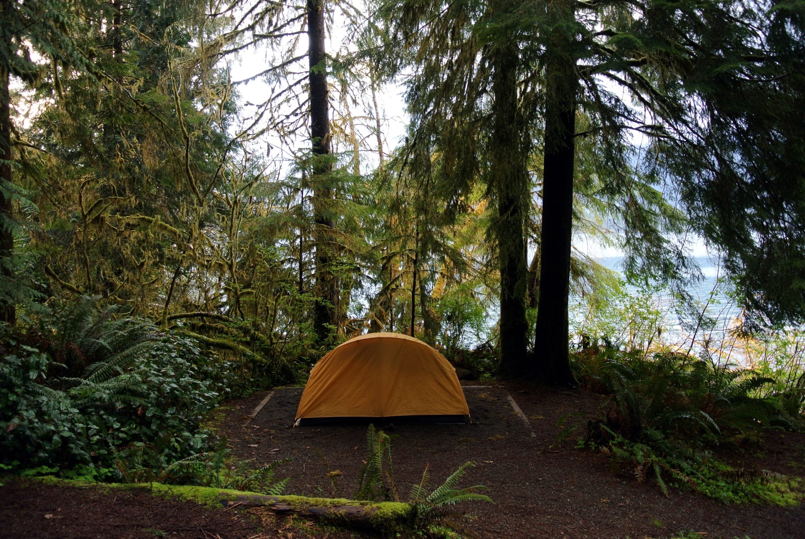
Header photo: camping in the rainforest on the shore of Lake Quinault, by Adbar, licensed under CC BY-SA 3.0.
Hero photo: a campsite in the rainforest at Lake Quinault, by Adbar, licensed CC BY-SA 3.0.
Before you go
That is the whole idea behind the Explore Washington State Card. Free to carry, with a little something waiting at participating places when you visit. Your zip code is a vote for which towns we sign up next, and our weekly Washington travel newsletter starts landing right away.
Get your free card- About the Author
- Latest Posts
Explore Washington State has been covering the real Washington for more than a decade. State parks, small towns, back roads, rest stops, and the people who make this place worth exploring. What started as a hyperlocal project covering individual communities grew into a full media project with more than 340 podcast episodes, a weekly newsletter with over 6,200 subscribers, and coverage of all 146 Washington State Parks. The content here comes from people who have actually been to these places: locals, regulars, and lifelong Washington residents who care more about getting it right than getting clicks.


