
The Yakima River Canyon: The Drive Most Washingtonians Skip
Saturday Verdict: Worth a Saturday for the drive and a hike. Worth a weekend if you fish, float, or camp.
The Yakima River Canyon is the 25-mile stretch of State Route 821 that connects Ellensburg and Yakima through basalt cliffs and high desert. Most people on I-82 between Seattle and the Tri-Cities have never turned south at Thrall Road. They should.
This is a working canyon, not a postcard. The river flows the same way whether you fish it, float it, or just pull over and watch a bighorn ram on a ledge above your truck. The reward is the same. You spent a day somewhere most Washington residents drive past.
Bring a thermos. There is no coffee in the canyon.
What’s Actually in the Canyon
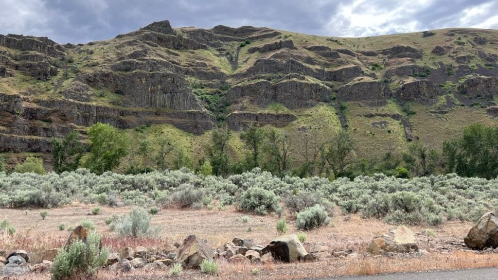
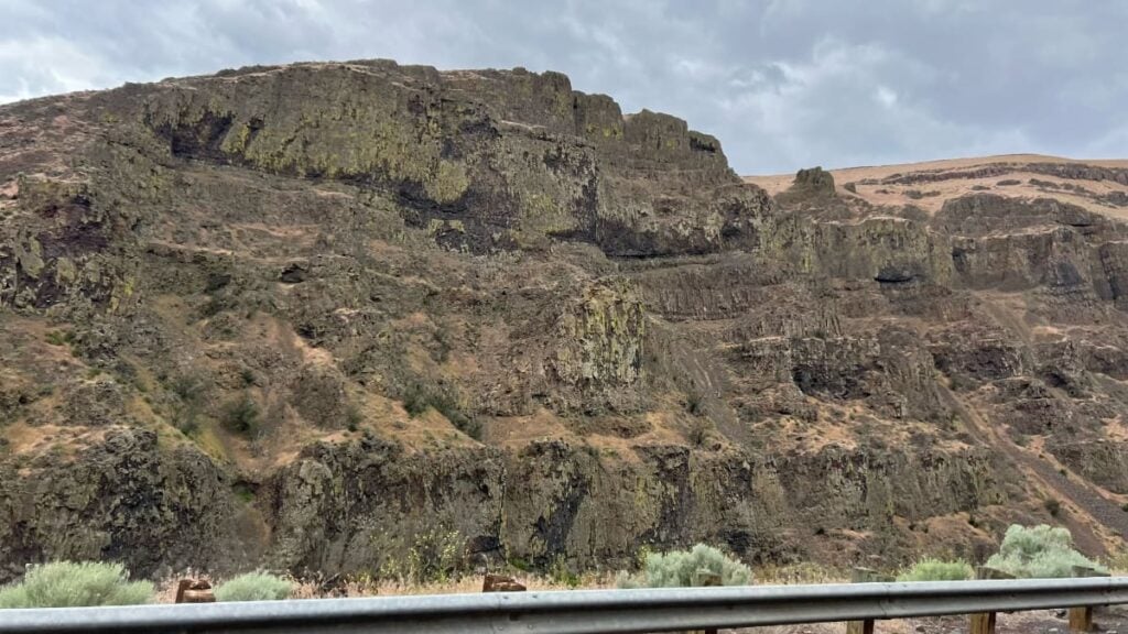
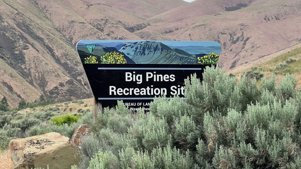
The Yakima River bends through about 27 miles of basalt and sage between Ellensburg and Selah. The road that follows it is SR 821, a Washington State Scenic Byway. The BLM manages roughly 9,000 acres along the corridor, with five developed river access sites, four with overnight camping: Bighorn (day use only), Umtanum, Lmuma Creek, Big Pines, and Roza.
The cliffs above the river reach more than 2,000 feet in places. They are basalt columns from the Columbia River Basalt flows, stacked and layered like cordwood. The river itself is a Blue Ribbon trout stream managed for catch and release. The wildlife is the densest concentration of nesting hawks, eagles, and falcons in the state, with a resident bighorn sheep herd on the slopes and occasional elk along the riverbanks.
A lot of the canyon’s public access exists because conservation groups bought working ranches and turned them over to the BLM. Western Rivers Conservancy has been the main mover; the Land and Water Conservation Fund did the federal share. That backstory is worth knowing if you camp at Umtanum or hike Umtanum Creek. The land was a private cattle operation within the last generation.
You can do the whole drive in 40 minutes. You can also spend three days here without running out of reasons to stay.
The Drive: SR 821 from Ellensburg to Yakima
The northern entrance is south of Ellensburg. Take I-90 to Exit 109, then I-82 east about 3.5 miles to Exit 3 (Thrall Road), then SR 821 south. The southern entrance is at Selah, off I-82 Exit 26. Either direction works. The view is the same.
The road hugs the river. Speed limits drop into the low 40s through the canyon and there are pullouts and developed turnouts at most of the recreation sites. Stop at least once even if you are not getting out for long. The view is different from a moving truck.
Mileposts to know, counted from the south end at Roza Dam:
- Milepost 7. Roza Recreation Site. Half a mile above Roza Dam. Smallest campground (six shaded sites), good day use access.
- Milepost 10. Big Pines Recreation Site. The largest campground in the canyon at 42 sites. Day use parking for 120 vehicles. The most reliable place to launch a float.
- Milepost 12. Lmuma Creek. Smaller site, river access.
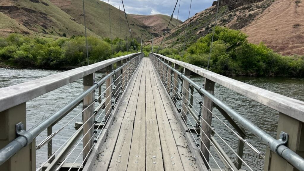
- Milepost 16. Umtanum Recreation Site. Suspension bridge across the river, trailhead for the canyon’s best hike, the most consistent bighorn viewing.
If you are driving the whole canyon for the first time, plan on at least an hour with stops. Plan two hours if you want to walk down to the river at Umtanum.
One thing nobody tells you: there is no gas, no cell service, and no drinking water in the canyon. Fill the tank in Ellensburg or Selah and bring more water than you think you need. Cell signal disappears around milepost 17 and does not come back until you are out the other side.
Bighorn Sheep, Raptors, and the Cliffs They Live In
The Yakima Canyon herd is one of the most visible bighorn sheep populations in Washington. The animals were reintroduced decades ago and now spend most of the year on the canyon’s slopes. Sightings are most consistent at the Umtanum Recreation Site, particularly on the cliffs above the swinging bridge and along the lower stretch of the Umtanum Creek trail.
Spring is the best season for sheep. The rams come down lower in late winter and early spring, the lambs show up in May, and the herd is generally easier to spot before the heat pushes them higher. Bring binoculars. The sheep blend into the basalt better than you would expect.
The raptors are the other resident headliner. The canyon’s cliff crevices are nesting habitat for red-tailed hawks, golden and bald eagles, and prairie falcons. Ospreys are in the canyon too but they nest on snags and platforms along the river, not on the cliffs. The bald eagles are easiest to find in winter when they hunt the open water of the river. The prairie falcons are the canyon’s specialty, and the cliffs above Umtanum are reliable.
Drive the canyon on any clear morning and you will spot them: people pulled over on the shoulder, tripods out, lenses the size of a coffee can pointed straight at the cliff face. Not at the river. Not at a viewpoint. At the rock. What do they know that you don’t?
If you are working the canyon and want a guaranteed wildlife stop on the same trip, the WDFW’s Oak Creek Wildlife Area sits about 30 minutes west of the south end of the canyon on US 12. Winter is when it works hardest. The state runs an elk feeding program there from late fall through early spring, and the viewing area regularly holds hundreds of animals at once. Pair Oak Creek with the canyon for a January day and you will see more big mammals in eight hours than most Washington itineraries deliver in a month.
Fly Fishing the Blue Ribbon Stretch
The Yakima is Washington’s only Blue Ribbon trout stream. The whole canyon section is managed catch and release with selective gear rules. Single barbless hooks. No bait. The fish are wild rainbows and cutthroat, and they are not stocked. They are also pickier than most rivers’ fish, which is part of why people drive across the state to try them.
The fishing year breaks into two reliable windows:
- March through June. Spring is when the bigger fish come up. Hatches are heavy: Skwala stoneflies in March and April, March Browns through April and May, then Salmonflies and caddis as the season builds. Wade fishing works in early March under low flows, but late April through June brings snowmelt runoff and early irrigation releases that can push the river over 2,000 CFS and well past wadable. Most of the spring’s reliable wade window is the first few weeks of March and the early April stretch before runoff hits; after that, float fishing is the better call.
- October. Fall is, by some guides’ read, the best season of all. Irrigation releases taper, the October Caddis hatch hits hard, and the crowds are gone. Wade fishing comes back into reach as flows drop under 1,500 CFS (ideal closer to 1,000). Float water settles into the 2,000 to 3,500 CFS range that drift boats prefer.
July and August are fishable but the flows are high (around 4,000 CFS during irrigation releases) and the fish hold deep. This is when most floaters are on the water, which makes wade fishing harder and float fishing the better option.
Two shops run the canyon:
- Worley Bugger Fly Co. ($$ to $$$ guide trips). 1713 South Canyon Road, Ellensburg. Year round storefront shop in the heart of the Yakima Valley. Owner Steve Worley puts boats on the river most days in season.
- Red’s Fly Shop ($$ to $$$ guide trips). Inside the canyon at Canyon River Ranch, about 13 miles south of Ellensburg. Pro shop, lodge, and grill on the same property. The largest guide operation on the river. Most guided float trips you will see in the canyon come from here.
Both shops sell flies, rent gear, and run guided drift boat trips for two anglers per boat. Either is a fair starting point. If you want to fish out of the canyon for a day and end up at a lodge, Red’s is the easier logistic. If you want a shop in town to load up on flies and then drive in yourself, Worley Bugger is the move.
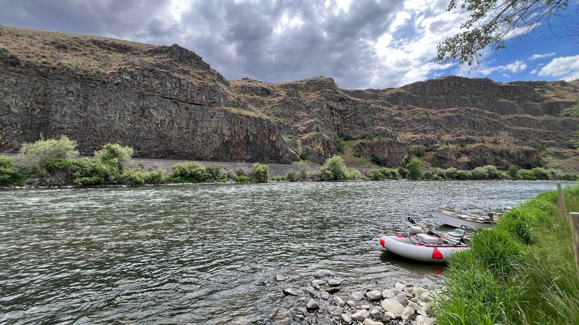
Floating and Rafting
Floating the canyon is the summer headline. Most people put in at Bighorn or Umtanum and take out at Big Pines or Roza, depending on how long they want to be on the water. Trips range from about an hour to a full day.
A few hard rules for floaters:
- Wear a life jacket. This is not optional. The Yakima looks placid and is not. Cold water, swift midriver current, and shoreline hazards do real damage. People drown in this canyon every season.
- Stay off the shoreline. The midriver current is the safer water. Most of the canyon’s hazards (overhanging branches, undercut banks, irrigation infrastructure) sit close to the banks.
- Watch the flow. Under 4,000 CFS is generally safe for casual floats. Above that, only experienced paddlers should be on the water.
The summer outfitters in the canyon:
- Rill Adventures. Guided rafting since 1996. Family friendly floats, scenic trips, and moonlight summer floats.
- Red’s Fly Shop and Canyon River Ranch. DIY paddle raft rentals for the 7 mile float from Bighorn or Umtanum (roughly 2 to 4 hours depending on flow). Also runs the Canyon Cruise party barge experience.
- River Rider. Beginner and family rafting based about 90 minutes from Seattle’s Eastside.
- Yakima River Tubing. Tube and shuttle service for the most casual floats.
We have a full breakdown of put-ins, take-outs, shuttle logistics, and rental options in our Guide to Floating the Yakima River. If you are planning a float specifically, start there.
Hiking: Umtanum Creek Canyon and Yakima Skyline
The canyon has two hikes worth driving for and a handful of shorter walks at the recreation sites.
Umtanum Creek Canyon Trail is the one most people do. Park at the Umtanum Recreation Site at milepost 16, walk across the suspension bridge over the Yakima, duck under the railroad tracks, and follow the canyon upstream. The trail is about 6.5 miles round trip with a moderate grade, basalt walls on both sides, and the best chance at bighorn sheep in the canyon. Old apple and walnut trees in the lower canyon are remnants of an early homestead. The wildflowers (arrowleaf balsamroot, lupine, larkspur, phlox) peak from April into early June. Bring water. The canyon holds heat in summer.
Yakima Skyline Trail is the harder option. The trailhead sits at the south end of the canyon, and WTA puts the basic route at 4.4 miles round trip; you can extend to about 6 miles by continuing to the saddle, or further to Gracie Point. The climb up to the ridge is steep, exposed, and waterless. The payoff is the view down into the canyon and east across the Columbia Basin. This is a cool weather hike. Do not attempt it in July.
The two trailheads sit on different agencies’ land, so the parking rules differ. Umtanum is BLM, so the $5 BLM day use fee at the recreation site covers the trailhead parking. Yakima Skyline is on state land and requires a Discover Pass. Bring the right pass for the trailhead you are using; one does not substitute for the other.
Camping the BLM Sites
The four BLM campgrounds along SR 821 are open all year. Reservations are taken May 1 through September 30 through Recreation.gov; the rest of the year sites are first come, first served. Overnight is $15 per site. Day use is $5 per vehicle. An America the Beautiful pass covers the day use fee at all four BLM sites.
| Campground | Sites | Notes |
|---|---|---|
| Big Pines (MP 10) | 42 | Largest in the canyon. Best for groups and float launches. |
| Umtanum (MP 16) | 18 | Six accessible sites at the main loop, 12 more at the south end. Suspension bridge and Umtanum Creek trailhead. |
| Lmuma Creek (MP 12) | 7 | River access, fewer amenities. |
| Roza (MP 7) | 6 | Smallest. Six shaded sites with accessible picnic tables. |
No hookups, no potable water, no dump station. Pack in everything including water. Vault toilets only.
2026 construction note: Big Pines and Roza campgrounds, including their boat ramps, will be closed for up to two weeks sometime between April 1 and October 31, 2026, for infrastructure improvements. Exact closure dates will be posted at Recreation.gov and the BLM Wenatchee Field Office site as construction schedules are finalized. Umtanum and Lmuma Creek campgrounds are not affected. Check Recreation.gov before booking Big Pines or Roza this summer.
The campgrounds fill on summer weekends. Reserve early or arrive Thursday for Friday through Sunday plans. Off season (October through April), even the best sites are usually open on arrival.
Where to Stay if You Are Not Camping
The canyon itself has one developed lodging option:
- The Lodge at Canyon River Ranch ($$$). 14700 SR 821, about 13 miles south of Ellensburg. Two bedroom condo style units with full kitchens, laundry, and patios. The lodge sits right on the river next to Red’s Fly Shop and the grill. Honest caveat: the BNSF tracks run between the lodge and the river, and freight trains pass through at night. Light sleepers should pack earplugs.
Outside the canyon, your two staging options are Ellensburg to the north and Yakima to the south. Ellensburg is the better fit for fishing or hiking days. Small downtown, decent breakfast, easy launch into the canyon at sunrise. Yakima is the better fit if you are combining the canyon with wine country to the south. Both keep you within 30 minutes of the canyon entrance.
When to Go
Each season offers a different version of the canyon. None of them are bad.
Spring (March to May). Wildflowers from late March into June. Bighorn sheep at their most visible. Fly fishing at its prime under low flows. The Yakima River Canyon Marathon runs in early April, which closes a section of SR 821 to traffic for race day. Bring a layer; mornings stay cold.
Summer (June to August). Float season. The canyon gets hot (high 80s and 90s are normal) and the BLM sites are full on weekends. The fishing is harder in midsummer flows but the floating is at its best.
Fall (September to October). The locals’ favorite. Cooler temperatures, golden cottonwoods along the river, fewer people, peak trout fishing in October. If you are going for the fishing and do not have a hard date, go now.
Winter (November to February). Quietest season. Bald eagles hunt the open water, the BLM sites are mostly empty, and the canyon takes on a stripped down, basalt and sky look that is its own thing. The road can pick up snow and ice in storms; check WSDOT before committing. Not a swimming or floating trip. This is a drive and walk season.
Who the Canyon Is For
The Yakima River Canyon rewards people who:
- Want a working outdoor day instead of a sightseeing tour. The canyon does not perform. You have to engage with it.
- Like wildlife you have to look for. The bighorns are real but not on cue. The raptors are everywhere and most visitors miss them.
- Fish, paddle, or want to learn either. The canyon is one of the best places in the state for both.
- Are tired of I-82 and want the slower line between Yakima and Ellensburg.
The canyon is probably not the right pick if you need food, fuel, cell service, or a curated experience between stops. It is a quiet corridor with infrastructure for outdoor activities, not for tourism. Bring everything you need and treat the drive itself as the destination.
A Note on Planning
A few practical things that get missed:
- Discover Pass for the Yakima Skyline trailhead (state land). Not required at the BLM river sites or the Umtanum trailhead, where the $5 BLM day use fee covers parking. An America the Beautiful pass covers those BLM fees automatically. Bring both if you are hiking both routes.
- No food in the canyon. Pack lunch. Canyon River Grill at Canyon River Ranch is the only restaurant on the corridor.
- Cell signal disappears for most of the drive. Download maps and any fishing or hike reports before you leave town.
- The river is colder than it looks. Fed by snowmelt even in midsummer. Plan accordingly if anyone is getting wet.
A simple packing list works for most canyon days: more water than you think you need, sunscreen, a hat, layers (mornings are cold even in summer), binoculars if you care about wildlife, a paper map or downloaded version, a full tank of gas, and a Discover Pass if you are hiking Yakima Skyline. Wading anglers add rubber soled wading boots (felt is banned in Washington), a Washington State fishing license, and barbless flies. Floaters add life jackets (required by law), a dry bag, and shoes that will not get sucked off in mud.
The canyon does not go anywhere. If you do not get there this spring, the bighorns will still be on the cliffs in October and the fish will still be in the river next March. But you have probably been telling yourself you would take the canyon road instead of I-82 for years now. This is the season to stop telling yourself that and just do the drive. Pack a thermos. Take Umtanum.
Frequently Asked Questions
What is the Yakima River Canyon?
The Yakima River Canyon is a 25-mile stretch of State Route 821 that follows the Yakima River through basalt cliffs and high desert between Ellensburg and Yakima. The BLM manages roughly 9,000 acres along the corridor, including five developed river access sites and four campgrounds. The river is Washington's only Blue Ribbon trout stream and the canyon supports the densest concentration of nesting hawks, eagles, and falcons in the state.
How long is the Yakima River Canyon scenic drive?
SR 821 runs 25 miles through the canyon between Selah (south end, off I-82 Exit 26) and Ellensburg (north end, via Thrall Road off I-82 Exit 3). The river itself meanders for about 27 miles. Driving time is roughly 40 minutes without stops, or an hour with a couple of pullouts. Two hours is realistic if you walk down to the river at Umtanum.
Where can you see bighorn sheep in the Yakima River Canyon?
The most consistent viewing is at the Umtanum Recreation Site at milepost 16, on the cliffs above the suspension bridge and along the lower stretch of the Umtanum Creek trail. Sheep are most visible in late winter and spring when they spend more time on lower slopes. Lambs typically appear in May. Bring binoculars.
Is the Yakima River Canyon worth visiting?
It is worth a Saturday for the drive and a hike. It is worth a weekend if you fish, float, or camp. The canyon does not perform for sightseers the way more famous Washington destinations do. The reward is in doing something on the river or with the wildlife, not in passive viewing.
When is the best time to visit Yakima River Canyon?
Spring (late March through May) is the best overall window. Wildflowers peak from late March into June, bighorn sheep are at their most visible, and fly fishing is at its prime under low flows. Summer (June to August) is float season but the canyon gets hot. Fall (September to October) is the locals' favorite for fishing and cottonwoods. Winter is quiet and good for eagle watching.
Can you camp in the Yakima River Canyon?
Yes. Four BLM campgrounds line SR 821: Big Pines (milepost 10, the largest at 42 sites), Umtanum (milepost 16, 18 sites total), Lmuma Creek (milepost 12, 7 sites), and Roza (milepost 7, 6 shaded sites). All are open all year. Reservations through Recreation.gov from May 1 to September 30; first come, first served October through April. Day use is $5 per vehicle, overnight is $15 per site. No hookups, no potable water, vault toilets only.
Do you need a permit to fish the Yakima River?
Yes. A Washington State freshwater fishing license is required. The Yakima Canyon section is managed catch and release with selective gear rules: single barbless hooks only, no bait. The fish are wild rainbow and cutthroat trout. The canyon is Washington's only Blue Ribbon trout stream.
- About the Author
- Latest Posts

Founder and editor of Explore Washington State since 2017. A lifelong Washington resident who has lived across Tacoma, Ellensburg, the west side, and now Wenatchee, Scott curates the most comprehensive guide to experiencing Washington State. He also hosts the Exploring Washington State podcast.


