

Hiking and Exploring Jolly Mountain
As I write this from the north Pasco countryside, early on a Friday afternoon, I look out the window of my study toward Badger Mountain, the Horse Heaven Hills and Jumpoff Joe. Typically, I would be able to see all three (although the wild roses growing outside my window obstruct my view of Jumpoff Joe, but the springtime blooms make it worth it). However, today I can hardly see my nearest neighbor, just a few hundred yards away, as the Washington wildfire smoke has settled atop the Columbia Basin, in much the same way our winter air inversions will lay down a thick blanket of fog in January.
It goes without saying (given we’ve all heard it a thousand times by now), that 2020 is quite possibly the strangest year the majority of currently living people have experienced. The late-August and September wildfires that have ravaged the West Coast are just another thing to add to the extensive list. I feel quite fortunate I was able to get out and do some exploring before the wildfires set in this year. One of those places I explored was the site of a 2017 — another year in which Washington was rocked by rampant wildfires — blaze in central Washington’s eastern Cascades; Jolly Mountain.

Traveling Through Central Washington
Back in early August my Texas Heeler Maizy and I hopped in my pickup and headed northwest from Pasco. Our destination? The Salmon La Sac area. The next morning we’d be summiting Jolly Mountain, which lies about an hour and a half northwest of Ellensburg.
From where we live north of Pasco, we followed the eastern side of the Columbia River, making our way past the orchards and countryside of Ringold, Basin City, and passing through Othello on our way to Vantage. After making the awe-inspiring jaunt across Wanapum Lake — a man-made reservoir on the Columbia River, a result of the construction of Wanapum Dam in 1963 — at Vantage, we forged ahead through the desert toward Ellensburg.
Ellensburg marks a breakpoint in the center of the state, as the broad, bulging hills become a little steeper and a little taller. The sagebrush and shrub steppe slowly give way to wind-blown pines, many with the tops angled toward the east, all snapped at some point by the prevailing winds at an almost eerily similar angle. The further west one travels on Interstate-90 the thicker the forest becomes, as the hills turn into mountains that slowly crowd closer to the freeway.
The snow-capped Cascades rise to the northwest as you make your way toward Cle Elum and into the mountains. After passing through Cle Elum and leaving Interstate-90, Maizy and I forged ahead to the small town of Roslyn, where the ‘90s sitcom “Northern Exposure” was filmed. Roslyn is a wonderful little town, their downtown featuring an ornate, old-west style atmosphere and a litany of shops and cafes to check out.
Salmon La Sac
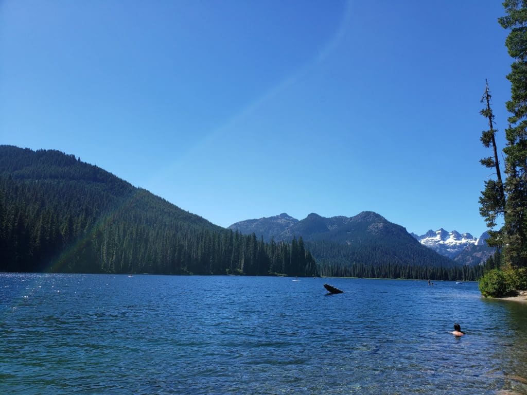
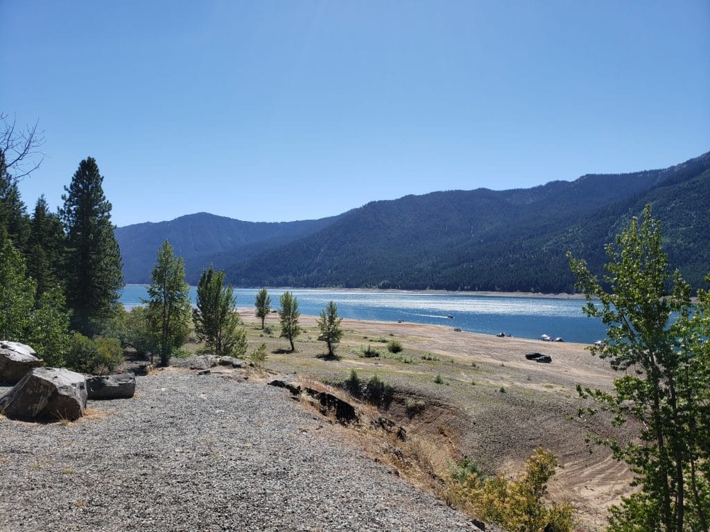
From Roslyn we continued north into Salmon La Sac country, skirting the eastern banks of Cle Elum Lake, which sprawled below to our left. Eventually, we turned off toward Cooper Lake, a smaller, yet popular lake to the northwest of Cle Elum Lake. Cooper Lake is breathtaking, where folks swim, kayak and sunbathe, and the snow-capped mountains rise above the fir and cedar dense mountains that surround the lake. Due to its beauty and recreation opportunities, it is a popular spot, and the day we visited, even in the midst of COVID, it seemed to be overcrowded, with people everywhere.
Given Maizy and I both prefer solitude to crowds, we went on past Cooper Lake, driving into the mountains to the west, and found a nice secluded spot to set up camp. Outside of a deer, some chipmunks, and a litany of birds, we didn’t see another soul the rest of the day.
With the burn ban in effect we didn’t have a campfire, but we hiked around camp a bit, and I spent much of the afternoon reading “The Word for Woman is Wilderness” by Abi Andrews, while sipping on Icicle Brewing’s Dark Persuasion German Chocolate Ale (Icicle Brewing is a Washington-based brewery, located in Leavenworth). After getting a good night’s sleep we woke up to the crisp mountain air, thick with the smell of petrichor and pines, and a heavy dew on the outside of the tent. The moisture and the cool air had Maizy and I a little chilly, being we’d just come from 100-degree heat in the Tri-Cities the day before.


Starting The Hike
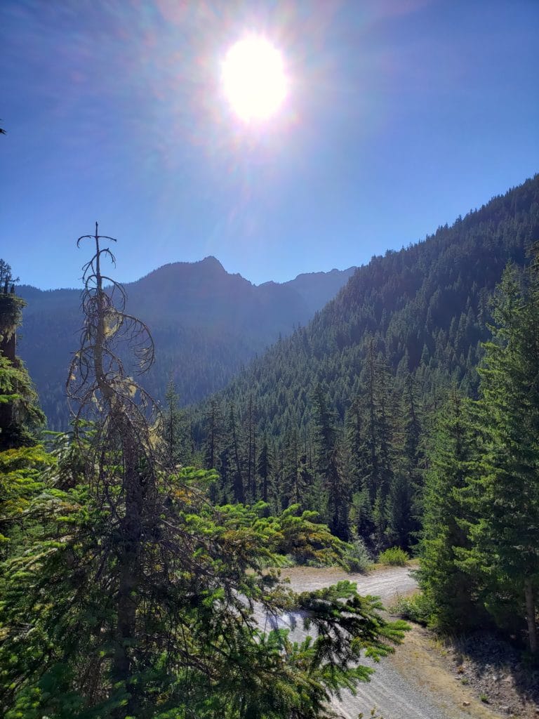
We ate breakfast (dog food for her, oatmeal and green tea for me), broke camp and headed for the Jolly Mountain trailhead. There are a couple different trailhead options, but we took off from the one at Cayuse Horse Camp. The trail begins thick in the woods, and almost right away the climb begins. The hike from there to the top was close to six miles, with approximately 3,000 feet in elevation gained. Needless to say, Maizy and I got our workout in for the day.
The trail is also used by mountain bikes and horseback riders, so it’s dusty and quite rocky in spots, making it a constant challenge to keep one’s footing.
About 4 miles in we came to a creek, the name of which I can’t recall. The creek was small and fast moving, and being a warm day, the water was strikingly cold. We stopped and got a drink, and I filled my canteen. I peered down into my canteen, and saw no visible debris, just clear, cold water. Unlike water from the city, this water had a crisp, refreshing taste to it. Maybe I was just dehydrated and delirious from the strenuous hike thus far, but I was pretty sure that was the best-tasting water I’d ever had in my life.
Getting To The Top
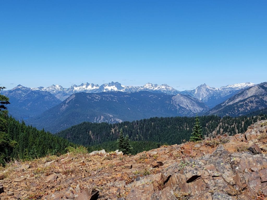
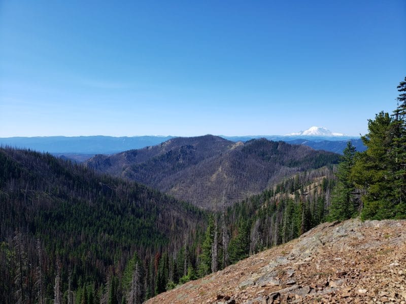
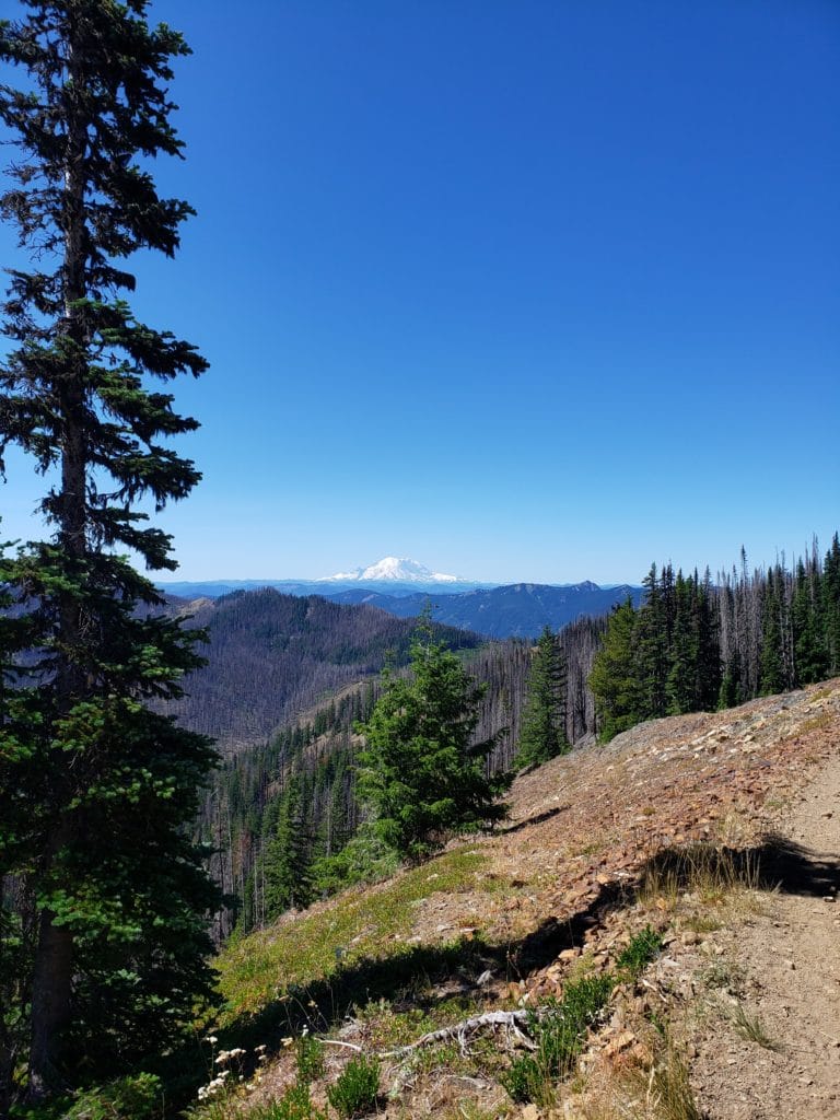
After a few more miles through the fir-dense woods, finally, the forest pulled back the curtains and the infinite blue sky opened up before us. In one direction lay a series of jagged peaks off in the distance, including those such as Chimney Rock, Bear’s Breast, Lemah Mountain, and Summit Chief Mountain. And to the southwest stood none other than the most prominent mountain in the state, Mount Rainier, glittering and white on the blue horizon.
There is something about Mount Rainier that can truly stop one in their tracks. Maizy and I found a rock to sit on and had a snack and some water, sitting in the direction of Mount Rainier. Truly a cathedral of American wilderness, it is always an honor to bask in the active volcano’s perpetually treacherous beauty on a clear day.


Fire Damage
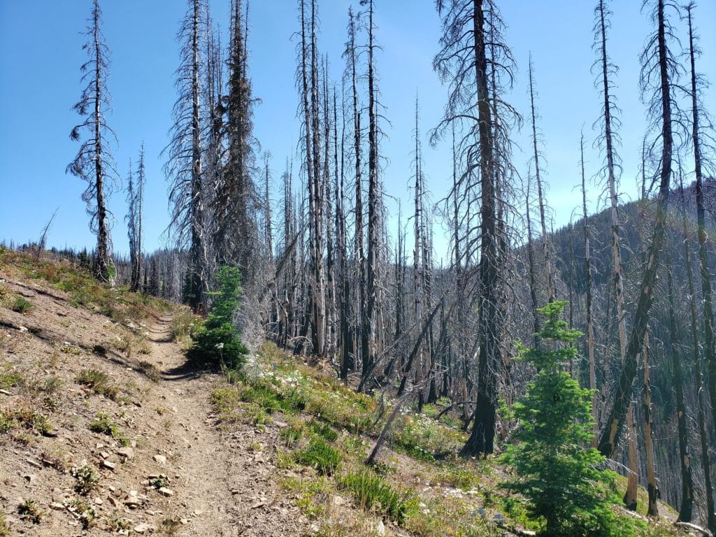
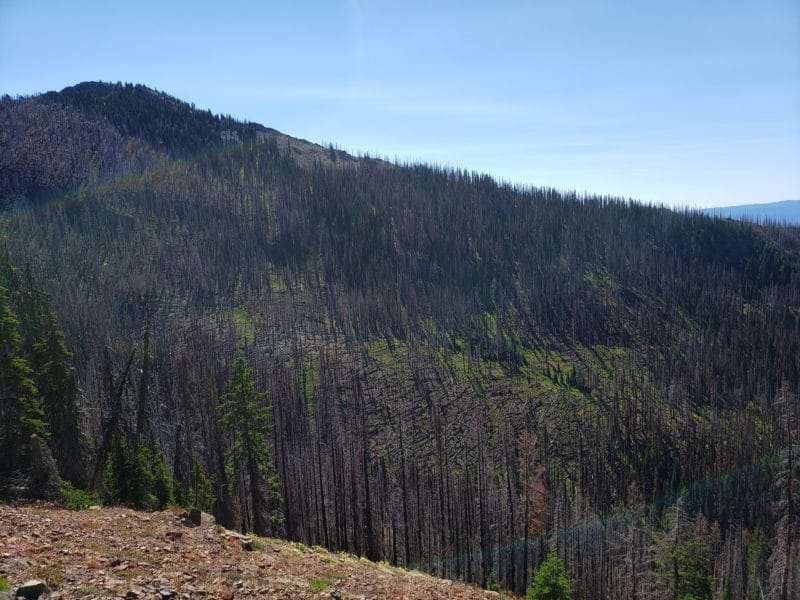
While the beauty from the top of Jolly Mountain was truly breathtaking, it was also humbling, and heartbreaking to witness what was left of the 37,000 acres that burned there in 2017. I’d walked through plenty of places hit by wildfires in the past, mostly on past hikes in Idaho or Montana, but this was perhaps the most barren aftermath I’d ever seen, particularly in comparison to the dense, lush forest I had just hiked through on the way up.
The fire had scorched just about everything, leaving just blackened tree-trunks with curled branches that were akin to the arthritic fingers of the Evil Queen in “Snow White.” From the top, one can see much of what had burned, as the forest has yet to make a recovery on the ridges and mountain sides that the fire consumed.
After getting our fill of the beauty, as well as the carnage, at the top, Maizy and I made our way back down the mountain. By the end of the hike we were thankful for the sight of my pickup, as the hike had tuckered out the both of us.
We stopped and had a pleasant chat with the horse camp caretaker and a forest service ranger for a few minutes, and per the forest ranger’s advice, I decided to check out Basecamp Books and Bites for lunch in Roslyn. I was thankful for her recommendation, as my sandwich there was phenomenal, and the unique shop was truly a delight. I picked up a sticker and a t-shirt from Basecamp as well, and Maizy and I got back on the road, headed for home.
On the way back home we took a different route. After crossing the river at Vantage and re-entering the shrub steppe, we headed south, following the river, and took in views of the arid and sagebrush-riddled Saddle Mountains and Sentinel Bluffs, passed the Wanapum National Heritage Site, and wound through the orchards and vineyards of Mattawa and Desert Aire.
We crossed back over the Columbia at Vernita Bridge, the Hanford Reach National Monument area and Hanford Site stretching out to our left. From there, we slowly curved toward the east, nothing but miles and miles of shrub steppe stretching in all directions, the broad side of Rattlesnake Mountain looking over us from the right, and the Tri-Cities coming into view ahead of us.
While the trip never even took us over the pass to the western slopes of the Cascades, we still experienced two distinctly different climates, ecosystems and environments, jumping from the dry, unforgiving desert, into the sheer, steep, thickly-wooded eastern Cascades, and back again.

Today, as the wildfire smoke continues to thicken, not only here in the Tri-Cities, and not only in the state of Washington, but all along the west coast, I think of the families, wildlife, and entire ecosystems that have been displaced, damaged, and destroyed as a result. My heart goes out to them all, and my deepest thanks goes out to the brave people out in the thick of it, fighting to contain and protect people, places, forests, and grasslands.
Here’s to hoping the autumn rains come soon and dampen the fires, and that all of us in the west will soon have clean mountain, desert, coastal, and prairie air to breathe again in the near future.


